More Intrepid Zone Results - Looking Good
posted on
Dec 05, 2012 06:49AM

NI 43-101 Resources of 3.42M oz. Au Indicated and 3.17M oz. Au Inferred (Feb. 2011)

RR.TSX
TORONTO, Dec. 5, 2012 /CNW/ - Rainy River Resources Ltd. ("Rainy River" or the "Company" (RR.TSX)) is pleased to announce further assay results from the Intrepid Zone ("Intrepid") at the Rainy River Gold Project ("RRGP") in northwestern Ontario. Results are summarized in Table 1.
HIGHLIGHTS
INTREPID - LATEST DRILL HOLE RESULTS
To date, 51 diamond drill holes have intersected the Intrepid Zone over a 335 metre strike length, and have traced the mineralization down dip for 450 metres.
Results Suggestive of Potential Open Pit Mineralization
Eleven of the eighteen drill holes reported in today's Intrepid Zone results show widths suggestive of open pit mining potential, with wide zones of near-surface gold mineralization. Drill hole NR121442 intersected 1.9 grams per tonne ("g/t") gold and 23.4 g/t silver over 57.0 metres, which represents the widest intersection to date. This hole remains open to the east. Widths and grades are comparable to those of the ODM Zone, with thickness and grade increasing as drills move eastward.
Drill hole NR121448 intersected 1.8 g/t gold and 22.3 g/t silver over 28.5 metres, starting at a vertical depth of 45 metres, while NR121446 intersected 2.9 g/t gold and 10.6 g/t silver over 33.0 metres, at a vertical depth of 79 metres. These drill results show significantly larger widths than seen in previous drill results.
These holes all lie immediately east of the Intrepid discovery hole NR121258, reported October 22, 2012.
Results Suggestive of Potential Underground Mineralization
Seven of the eighteen holes reported today were drilled to the west of the wider zones of mineralization. These holes returned significant grades and widths which could potentially become mineable via the planned underground decline, with high-quality ounces brought forward earlier in the underground mine life. NR121424 intersected 8.4 g/t gold and 72.4 g/t silver over 4.5 metres at a vertical depth of 400 metres, and NR121427 intersected 6.0 g/t Au and 7.0 g/t silver over 3.0 metres at a vertical depth of 404 metres. These two holes are over 100 metres down plunge of Rainy River's previous drill intersections at Intrepid. Additionally, NR121461 intersected 7.5 g/t gold and 23.3 g/t silver over 7.5 metres at a vertical depth of 205 metres.
Maps and Images
Note: Map 2 to Map 5 are cross sections moving progressively to the east.
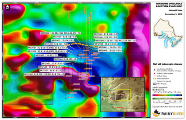
Map 1 - Diamond Drill Hole Location Plan Map
Map 2 - 427310 E Cross Section
Map 3 - 427460 E Cross Section
Map 4 - 427489 E Cross Section
Map 5 - 427512 E Cross Section
Map 6 - Vertical Longitudinal Section
COMMENTARY
Raymond Threlkeld, President and CEO of Rainy River Resources Ltd., commented: "Today's results include some of the best intersections we have seen to date at the Intrepid Zone, providing further support for the open pit potential of this exciting new discovery, in addition to the potential contribution of high-quality ounces early in the underground mine life. Located one kilometre away from the main Rainy River Gold Project, and with 51 drill holes completed, Intrepid now has a 335-metre strike length and measures 450 metres down dip. The Intrepid Zone continues to expand eastward, widening as it nears the surface, and demonstrating very good potential for the Rainy River Gold Project. As we move into the development stage with our namesake project, we remain committed to realizing more of the exploration upside in the Rainy River gold district."
Qualified persons
Rainy River's exploration program in Richardson Township is being supervised by Kerry Sparkes, P.Geo., Vice-President Exploration, a Qualified Person as defined by National Instrument 43-101. Mr. Sparkes, P.Geo. is also the person responsible for the content of this news release. The Company has a rigorous QA/QC program in place to ensure best practices in sampling and analysis of drill core. All drill core is marked for sampling and then split in half with a diamond saw blade. Samples are placed in sealed bags with security tags. All samples were assayed using a standard fire assay, 30 gram nominal sample weight with an AA finish. Over-limit samples were re-assayed with a gravimetric finish. Samples with visible gold were automatically analyzed for Ore Grade by 1000 g screen fire assay, with coarse and fine fractions being combined proportionately and the fine fraction being assayed twice. Standards, blanks and duplicates are inserted every 25 metres. ALS Canada Ltd. performed primary assaying, with duplicates being analyzed at Activation Laboratories Ltd. ALS Canada Ltd. and Activation Laboratories Ltd. implements independent QA/QC protocols that include the insertion of certified blanks and standards as part of their routine analysis.
About Rainy River
Rainy River Resources Ltd. is a Canadian precious metals exploration company whose key asset is the Rainy River Gold Project, a large gold system centred in Richardson Township (part of Chapple Township). As of September 30, 2012, the Company had approximately $62 million in cash and cash equivalents and short-term investments, and remains well funded for its 2012 plans to 1) commence a feasibility level study on the RRGP; 2) continue growing the existing resource through exploration; 3) conduct a condemnation program in areas identified for potential mine facilities; and 4) continue regional exploration. RRGP is very well located in northwestern Ontario, near the U.S. border. It is accessed by a network of roads and is close to hydro-electric infrastructure. The Rainy River district has a skilled labour force and is one of the lowest-cost areas for mineral exploration and development in Canada. The Company is also working to advance the early-stage discoveries at its TPK Joint Venture Property, also in Ontario, where it can earn a 51% interest in the property from Northern Superior Resources Inc. Ontario has low political risk and, according to the annual Fraser Institute global survey of the mining industry, has consistently ranked as one of the top jurisdictions embracing mineral development.
RAINY RIVER RESOURCES LTD.
Raymond W. Threlkeld
President and CEO
CAUTIONARY NOTE REGARDING FORWARD-LOOKING STATEMENTS
This release includes certain statements that may be deemed to be "forward-looking statements". All statements in this release, other than statements of historical facts, that address events or developments that management of the Company expects, are forward-looking statements. These statements include the possible suitability of certain mineralized zones for open-pit mining and that reported mineralization from recent drill results will translated into confirmed resource calculations. Although management believes the expectations expressed in such forward-looking statements are based on reasonable assumptions, such statements are not guarantees of future performance, and actual results or developments may differ materially from those in the forward-looking statements. The Company undertakes no obligation to update these forward-looking statements if management's beliefs, estimates or opinions, or other factors, should change. Factors that could cause actual results to differ materially from those in forward-looking statements, include market prices, exploration and development successes, continued availability of capital and financing, and general economic, market or business conditions. Please see the public filings of the Company at www.sedar.com for further information.
TABLE 1
| HOLE ID | SECTION |
VERTICAL DEPTH (metres) |
FROM (metres) |
TO (metres) |
LENGTH (metres) |
Gold (g/t) |
Silver (g/t) |
| NR121416 | 427411 | 215 | 277.5 | 303.0 | 25.5 | 1.0 | 16.1 |
| NR121421 | 427355 | 343 | 388.5 | 432.0 | 43.5 | 1.3 | 7.6 |
| NR121422 | 427334 | 397 | 442.5 | 487.5 | 45.0 | 0.9 | 12.0 |
| NR121424 | 427294 | 404 | 457.5 | 478.5 | 21.0 | 2.8 | 20.0 |
| INCL | 427294 | 400 | 460.5 | 465.0 | 4.5 | 8.4 | 72.4 |
| NR121427 | 427256 | 404 | 472.5 | 475.5 | 3.0 | 6.0 | 7.0 |
| NR121431 | 427438 | 152 | 204.0 | 214.5 | 10.5 | 1.3 | 14.8 |
| NR121432 | 427378 | 266 | 324.0 | 373.5 | 49.5 | 0.9 | 7.9 |
| INCL | 427378 | 270 | 336.0 | 373.5 | 37.5 | 1.0 | 8.5 |
| NR121433 | 427442 | 176 | 225.0 | 234.0 | 9.0 | 2.7 | 24.8 |
| NR121441 | 427513 | 62 | 64.5 | 78.0 | 13.5 | 1.1 | 31.6 |
| NR121442 | 427510 | 103 | 96.0 | 153.0 | 57.0 | 1.9 | 23.4 |
| INCL | 427510 | 95 | 96.0 | 132.0 | 36.0 | 2.5 | 27.7 |
| NR121444 | 427454 | 205 | 276.0 | 280.5 | 4.5 | 5.4 | 18.5 |
| NR121445 | 427483 | 111 | 130.5 | 144.0 | 13.5 | 1.2 | 13.1 |
| INCL | 427482 | 114 | 136.5 | 144.0 | 7.5 | 1.6 | 20.9 |
| NR121446 | 427489 | 79 | 76.5 | 109.5 | 33.0 | 2.9 | 10.6 |
| NR121447 | 427466 | 141 | 172.5 | 183.0 | 10.5 | 2.7 | 30.6 |
| NR121448 | 427490 | 65 | 60.0 | 88.5 | 28.5 | 1.8 | 22.3 |
| NR121449 | 427460 | 102 | 114.0 | 138.0 | 24.0 | 1.3 | 20.6 |
| INCL | 427460 | 102 | 114.0 | 121.5 | 7.5 | 2.4 | 47.9 |
| NR121451 | 427386 | 227 | 282.0 | 327.0 | 45.0 | 1.2 | 8.5 |
| INCL | 427386 | 227 | 301.5 | 307.5 | 6.0 | 5.5 | 27.7 |
| NR121461 | 427255 | 205 | 273.0 | 280.5 | 7.5 | 7.5 | 23.3 |
*Vertical depth is calculated by determining the vertical depth at the mid-point of the down-hole intersection.
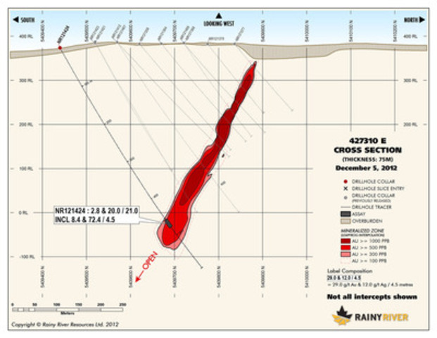
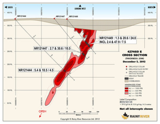
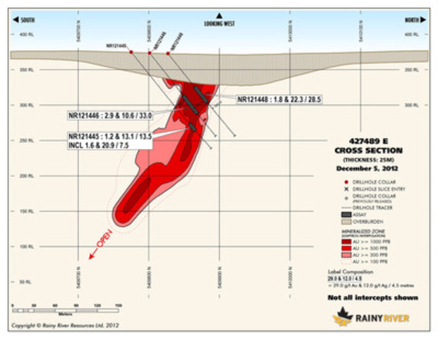
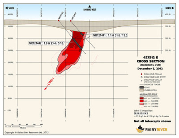
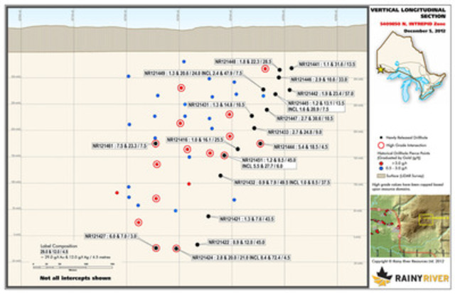
Image with caption: "Map 1 - Diamond Drill Hole Location Plan Map (CNW Group/Rainy River Resources)". Image available at: http://photos.newswire.ca/images/download/20121205_C6310_PHOTO_EN_21572.jpg
Image with caption: "Map 2 - 427310 E Cross Section (CNW Group/Rainy River Resources)". Image available at: http://photos.newswire.ca/images/download/20121205_C6310_PHOTO_EN_21573.jpg
Image with caption: "Map 3 - 427460 E Cross Section (CNW Group/Rainy River Resources)". Image available at: http://photos.newswire.ca/images/download/20121205_C6310_PHOTO_EN_21574.jpg
Image with caption: "Map 4 - 427489 E Cross Section (CNW Group/Rainy River Resources)". Image available at: http://photos.newswire.ca/images/download/20121205_C6310_PHOTO_EN_21575.jpg
Image with caption: "Map 5 - 427512 E Cross Section (CNW Group/Rainy River Resources)". Image available at: http://photos.newswire.ca/images/download/20121205_C6310_PHOTO_EN_21576.jpg
Image with caption: "Map 6 - Vertical Longitudinal Section (CNW Group/Rainy River Resources)". Image available at: http://photos.newswire.ca/images/download/20121205_C6310_PHOTO_EN_21577.jpg
SOURCE: Rainy River Resources
For further information:
Indi Gopinathan
Director, Investor Relations
Telephone: 416-645-7289
E-mail: igopinathan@RainyRiverResources.com