Why Durango Resources?
DGO-TSXV
Projects Staked and Acquired at Strategically Located Geological Locations
100% interest in the Trove and East Barry claims, Windfall Camp Quebec
- 9500 Hectares
- 2,100m drilled over nine holes on the Trove Property at an average depth of 233m
- 20 high priority holes planned the Trove Property between 200 and 800 meters deep
- Surrounded by Osisko
- Currently the most active gold exploration camp in Canada
- Quebec is one of the most geologically prospective and pro-mining jurisdictions in the world today.
- Located at the intersection of two gold bearing faults: Rouleau and Barry
- Coincident geophysical anomalies point to potential mineralzation
- The East Barry claims host a 10km gold trend
- 4km south of Bonterra's Gladiator deposit
- Durango identified a high priority target currently being drilled.
Discovery Property, Quebec
- Situated on strike with the Troilus Gold mine & is direct neighbour of Troilus Gold.
- Assayed over 40 g/t gold at surface in channel sampling
- Received Drill permits
NMX Property, Quebce
- Adjoins Nemaska Lithium’s Whabouchi Deposit which is one of the richest spodumene deposits in the world in terms of volume and grade.
- assays returned lithium and cesium in pegmatite at surface within walking distance of the Whabouchi Mine
- received drill permits for exploration drilling and
- Plan to test drill the project in early 2022.
40% Inside Ownership
- Marcy Kiesman, President & CEO owns 16%


Exploration Plans on Trove and East Barry
- Currently Drilling both properties
- Trenching and drilling of 15 priority targets provided drill locations

Properties
Trove -Windfall Lake Quebec
Durango owns 100% interest in the Trove claims, which are surrounded by Osisko Mining Inc. (TSX: OSK), in the Windfall Lake area between Val d'Or and Chibougamau, Quebec.
- Durango owns 100% interest in the Trove claims which are surrounded by Osisko Mining Inc. in the Windfall Lake area between Val d’Or and Chibougamau, Québec.
- The 1,150-hectare property has a coincidence of
- Gold in till with Magnetic highs
- Multiple Induced Polarization (“IP”) anomalies
- Two ( 2 ) faults crosscutting the property.
- Faults are proven controls to gold bearing mineralization in both the Gladiator deposit of Bonterra Resources Inc. (TSX.V: BTR) (“Bonterra”) and the Windfall Lake deposit of Osisko.
- Osisko has drilled on various claims surrounding the Trove property and encountered gold on multiple sides of the Trove.
- The collars of several holes which intersected gold are within walking distance of Durango’s Trove border.
- The Trove property is drill ready and has 15 high-priority planned drill holes
Till Sampling at Trove:
Five blocks of claims ware visited and sampled in November 2017.
- Thirty-six (36) 5kg till and thirty-six (36) duplicate soil samples were collected and analyzed for:
- fine fraction analysis,
- sampled for gold grain count
- dense fraction.
- Of the 36 till samples taken from the area,
- 17 samples representing 47% of the samples collected returned gold grains,
- 25 till samples of the multi-element assays reported gold anomalies between 5 ppb and 3480 ppb representing 74% of the samples collected.

Trove, Quebec
Durango owns 100% interest in the Trove claims, which are surrounded by Osisko Mining Inc. (TSX: OSK) , in the Windfall Lake area between Val d'Or and Chibougamau, Quebec. The 1,185 hectare property is compelling due to the coincidence of gold found in tills coinciding with magnetic highs, several Induced Polarization anomalies and two faults crosscutting the property. The fault systems north and south of the Trove, control gold mineralization elsewhere, indicating the Trove has excellent exploration potential. Durango received all the final drill permits for the Trove property in September 2019 and is undergoing its final reviewing process for the proposed 3,000m drill program.
Geophysics Program:
Conducted induced polarization (“IP”) survey on its North and East claim blocks at Windfall Lake.
- Completed during the spring and summer of 2018 with the purpose of finding anomalous geophysical targets
- Target areas for the IP survey were determined based on the high gold particles discovered through Till Sampling Program
- The IP survey targeted three areas named P1, P2, and P3.
- A total of 51 individual IP anomalies were grouped as 27 chargeable lineaments and were further defined in P1 and P2 targets.
- The two targets are in direct contact with Osisko Mining Inc.’s claims and cross cut by NE-SW fault systems striking towards the reported Windfall Lake main mineralized system.
History of Trove:
Durango entered a JV with BonTerra on Trove in 2017
September 11, 2018, BonTerra advised Durango in writing that it will not be proceeding with further exploration activities on the Trove Property
Pursuant to the terms of the Option Agreement, Durango will retain its 100% interest in the Trove Property.
- Allowed for exploration and drilling without dilution to shareholders.
- Durango received cash payments of $300,000 and 3 million common shares of BonTerra satisfying the terms up to and including the first anniversary.
EAST BARRY - Currently Drilling
- Drilling two exploration holes on the East Barry Property budgeted for depths of approximately 750m each.
- Test high priority targets coincident with high till anomalies of up to 2.19 g/t gold and pristine gold grains in till trend
The East Barry Property is a compelling target to host gold mineralization.
- 7,740 hectares, bordering Osisko Mining Inc. (TSX:OSK) on the west and Bonterra Resources Inc. (TSXV:BTR) on the north
- Five-kilometre gold trend on the East Barry property,
- Till sampling programs
- including over 2 g/t gold along an established 5km trend of gold from till assays
- Till samples go to greater depths (1m+) to reach bedraock contact due to amount of overburden
- New outcrops have been discovered on high ground providing key geological information for the area
The East Barry Property covers a northeasterly trending linear structural contact in sync with Till sampling
Further Geophysical studies planned to further define gold targets include;
- Additional till sampling,
- Induced polarization surveys.
These programs at Barry are designed to pin down structural targets along the 5km southern contact

East Barry, Quebec
Durango owns 100% interest in the East Barry claims which run parallel to Trove claims. The East Barry block is over 6,100 hectares in size and borders the eastern perimeter of Osisko's holdings and the southern perimeter of Bonterra's holdings and is less than 4km south of the Gladiator deposit. The East Barry claims host a gold trend which covers approximately 10km in length and is subparallel to the main Barry Fault held by Osisko. In 2018 a till sampling program was conducted and one of the till samples returned fourty-two (42) pristine gold grains with reported gold values of 2.184 g/t Au. A high count of pristine gold grains indicates that the gold has travelled a very short distance from its source. The East Barry block underwent an Induced Polarization survey in 2018 which identified a high priority target coincident with the high count of pristine gold grains
Other Projects:
Discovery Property
- Durango is situated on strike with the Troilus Gold mine is direct neighbour of Troilus Gold.
-
Troilus Gold has produced 2M oz of gold and 70,000 oz of copper and currently has a gold mineral resource of over 8M oz of indicated and inferred gold. They believe they are in a gold corridor due to additional gold discoveries identified south of the mine. As such Troilus has expanded their claim size to 142,400 hectares.
-
Durango is on strike and adjacent to Troilus and has recently assayed over 40 g/t gold at surface in channel sampling. The property has excellent road access and drill permits are in place.
The Discovery Property is located 100km north of Chibougamau, Quebec and is approximately 60km southwest of the past producing Troilus Mine. The Troilus Mine produced over 2M ounces of gold from 1997-2010 and has remaining indicated resources of another 4.71M ounces (Troilus website). The Discovery property of Durango is approximately 4,200 hectares in size and covers an important geological structure in the Frotet Evans greenstone belt which has a history of producing gold and copper. The Discovery Property is located on strike with Troilus Gold Corp. and Osisko Mining Inc. and has road access and hydro lines crossing the property.

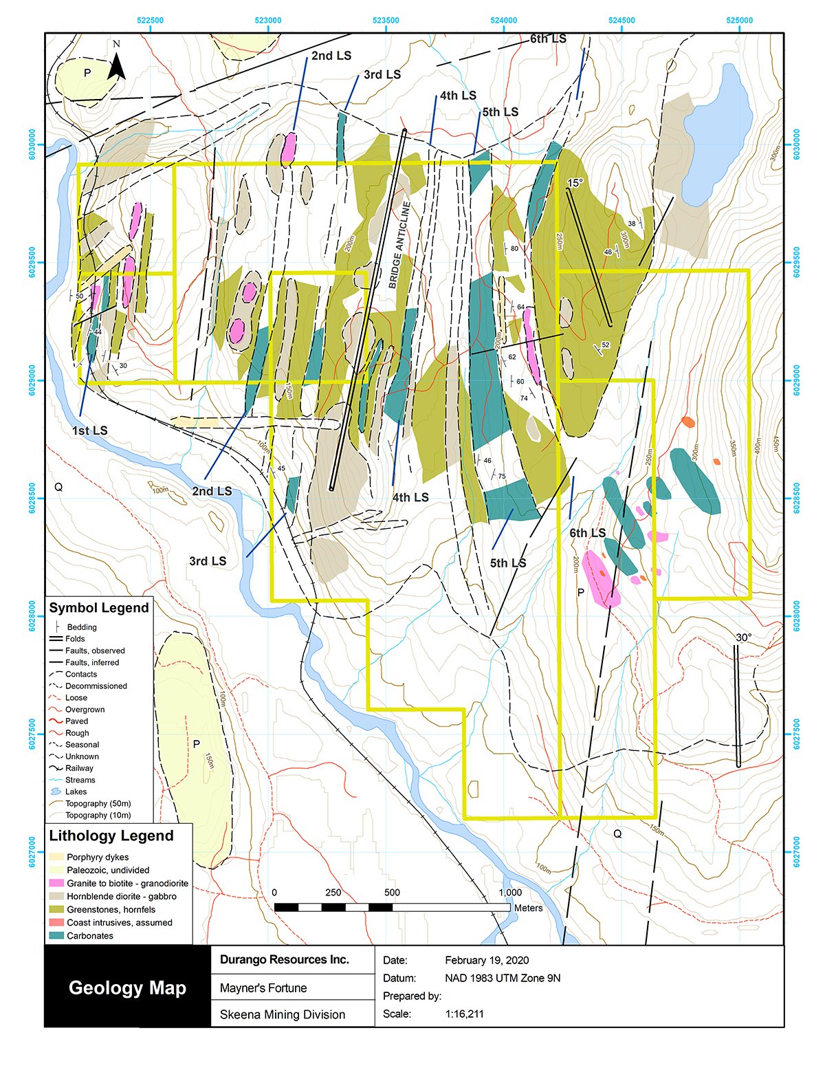
Mayner's Fortune, BC
The Mayner’s Fortune limestone property is located in the Skeena Mining Division approximately 7.5 kilometres south west of Terrace, B.C. and 4 kilometres west of Lakelse Lake on Lakelse River. The property has logging road access and the Canadian National Railway cuts through the property along its route between Terrace and Kitimat.
The area of interest at Mayner’s Fortune consists of a two kilometre thick metasedimentary sequence hosting six sub-parallel N to NE-striking limestone units of variable thickness.
Durango has received permit approval from the British Columbia Ministry of Energy, Mines and Petroleum Resources for its bulk tonnage application on the Mayner’s Fortune Limestone Project in northern B.C. The bulk tonnage permit will allow Durango to determine the volume and quality of limestone unit #5 and provide an understanding of the potential tonnage for the unit. Unit #5 has been measured at 1.6km long and Durango is interested in determining the calcium carbonate levels at depth. Limestone units #1 and #3 are already known to be of high quality and generous size.
Limestone unit #1 has an historical inferred reserves for the 10-mile zone measured 454,000 tonnes grading 96.3 per cent limestone, which seems probable based on the observations from the 2017 site visit. Representative samples taken from outcrop sections of the Mayner’s Fortune occurrence assayed calcium carbonate levels at 97.6%. Additional assays in the area have returned calcium carbonate levels up to 99.9% at surface.
The technical contents of this page were approved by George Yordanov, PGeo, an independent qualified person as defined by National Instrument 43-101. The property has not yet been the subject of an NI 43-101 report.

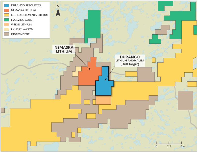
NMX East Property
- Applied for 2 hole drill program
Durango's 100%-owned NMX East property is adjacent to the Whabouchi Lithium Deposit and Hydromet Plant Project, which has been the subject of a Feasibility Study and is planned to be developed into an open pit mining operation. This plant will produce lithium hydroxide, which is used in cathodes of rechargeable batteries.
Results from the field reconnaissance survey conducted by Durango on the NMX East property clearly indicate the discovery of distinct lithium-bearing intrusions, which have been characterized as LCT (lithium-cesium-tantalum) pegmatites, and the generation of clear drilling targets.
Interpretation of Lithium, Cesium, Tantalum, and Rubidium Anomalies
The Nemiscau Region exhibits a markedly limited amount of bedrock exposure, which produces a very challenging environment for surface sampling. On average, there is approximately less than 5% exposure on the NMX East property and a large portion of the surrounding region. Evidence suggests that the majority of pegmatite bodies in the Nemiscau Region are obscured beneath the glacial diamict which blankets the region (1). Nemaska Lithium Inc.'s recent drilling results also report mineralized intercepts as deep as 500 metres below surface. It is possible that viable lithium-bearing LCT pegmatites, which occur at surface on Durango’s NMX East property, could represent smaller exposures of potentially larger intrusions at depth, laterally, and along strike.

The technical contents of this page were approved by George Yordanov, PGeo, M.Sc., (#1612), a qualified person as defined by NI 43-101. The properties have not yet been the subject of a compliant NI 43-101 report.
Last changed at 01-Dec-2022 11:50AM by AGORACOM