Advancing 3 Key Atlantic Exploration Properties Simultaneously
Golden Promise, Keymet and South Quarry

Great Atlantic Resources Corp Profile
NEWFOUNDLAND
- Most advanced, highest priority and largest (13,000 hectares) property
- Located in central Newfoundland near Badger
- Property hosts multiple gold bearing quartz vein zones and zones of gold nearing quartz boulders
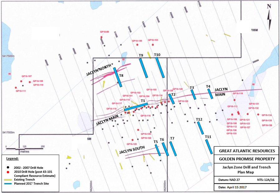
- Since the discovery of high grade boulders in 2002, multiple exploration programs have been conducted including approximately 22,000 meters of diamond drilling, a resource estimate and a bulk sample
- Six gold bearing quartz vein zones are located in the central region, referred to as the Jaclyn Zone
- Drill intersections exceeding 15 g/t Au over greater than 1 meter are reported. The Jaclyn Main Zone contains a NI 43-101 compliant (2008) inferred resource of 921,000 tonnes averaging 3.02 g/t Au (89,500 contained ounces of gold) at a 1 g/t Au cutoff


- High priority tungsten property with lithium potential, located in east-central Newfoundland
- Covers an area of 3600 hectares.
- Project contains tungsten bearing quartz-mica-feldspar pegmatite veins and tungsten bearing calc-silicate horizons, being discovered during the 1980s.
- Tungsten bearing veins occur in the northern region at a quarry called the South Quarry
- Numerous similar veins were reported in a 200 by 10 meter stripped area north of this quarry.
- A series of 27 vein channel samples in one part of this stripped area were reported to average 1.79% WO3.
- A near-by drill hole was reported to intersect 2.77% WO3 / 0.9 meters in altered limestone (possible skarn).
- Trenching and drilling in the southern region of the property intersected local narrow tungsten-bearing calc-silicate horizons.
- A 20 cm channel sample across one vein returned 2.96% WO3 while a grab sample from a 0.25 meter wide vein in the South Quarry returned 11.94% WO3. Host rocks are sediments and metasediments including calcareous layers (limestone reported locally). Granite intrusions are reported peripheral to the property. Some samples collected by Great Atlantic were anomalous for lithium (up to 297 ppm Li).
NEW BRUNSWICK

- The 1950/s Silver Mine facility was gutted by fire. Global recession and silver prices did not permit reproduction
- 4 Lead / Zinc / Silver zones
- Great Atlantic has defined drill targets
- Only 20 km from Xtrata's Brunswick 12 mine


- Porcupine is a precious metal – base metal – REE property, located in central New Brunswick
- Covers an area of approximately 1280 hectares
- Primary area of focus has been the northwest region where numerous individuals and companies explored dating back to the 1950
- Silver and base metal bearing float and bedrock is reported in this region, some boulders containing elevated gold
- One boulder sample was reported to return 13.6% Zn and 12.5% Pb.
- Base metal geochemical anomalies were reported in this northwest region. Rare Earth element geochemical anomalies have been reported on the property.
- 2012 trench revealed a mineralized shear zone with the best channel sample being 5.48% Zn, 1.08% Pb and 0.36% Cu over 1 metre
- Mineralized boulders were sampled from glacial till in trenches with one boulder sample returning 20.7% Pb, 6.89% Zn, 2.04% Cu and 122 g/t Ag.
NOVA SCOTIA

- Maclean Brook is a recently acquired precious metal - base metal property with graphite potential
- Located in eastern Nova Scotia on Cape Breton Island. The property covers approximately 1210 hectares and is an early-stage property (no reported diamond drilling).
- Polymetallic veins are reported in the northern region of the property. Visible gold was reported in panned samples along two brooks.
- 1993 boulder grab sample from this area was reported to return 1.50 g/t gold, greater than 50 g/t Ag, 5.76% lead, 3.79% zinc, 1.48% copper and 0.3% bismuth.
- Mineralized quartz-carbonate vein, reported to be 0.3 to 0.5 meters wide, was discovered in this area in 1994, with samples reported up to 1.45 g/t gold and 136.0 g/t silver.
- Historic trenches were located in 2012 and vein rubble grab samples collected, the highlight being a sample reported to return 7.28% zinc and 171 g/t silver. Mineralized quartz and quartz – carbonate veins are reported to cut metasediments of the George River Group and adjacent Precambrian - Cambrian granite.
- Mineralized veins have been reported to be associated with shearing and faulting.

- Mitchell Brook is a recently acquired lithium - gold property, located in eastern Nova Scotia.
- It is an early-stage property (no reported diamond drilling), covering an area of approximately 530 hectares.
- A lithium bearing pegmatite intrusion is reported within approximately 500 meters of the Mitchell Brook Property on adjacent mineral claims (Great Atlantic has no interest in these claims).
- 2 meter chip sample of the pegmatite from a 2010 trench was reported to return 5360 ppm Li (0.536% Li). Pegmatite boulders were reported in 2010 (no samples reported), some of which may occur within the Mitchell Brook Property
- Gold bearing quartz veins cutting metasediments are also reported within approximately 500 meters of the Mitchell Brook Property on the adjacent mineral claims.
- Samples collected in the 1950s from this occurrence were reported to assay 0.91, 0.60 and 0.243 oz. / ton Au. The Mitchell Brook Property is predominantly underlain by sediments - metasediments of the Cambrian - Ordovician Goldenville Formation, part of the Meguma Group.

Last changed at 23-Aug-2019 09:36AM by AGORACOM

